Where Is Chavez Ravine, Exactly?

Chavez Ravine does exist.
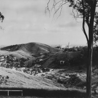
Glance at the USGS' topographic map of Los Angeles, and you'll find a narrow canyon labeled "Chavez Ravine," a steep-walled arroyo that arcs down from the highlands of Elysian Park toward the floodplain of the Los Angeles River.
And yet, most Angelenos are unaware of this canyon – or at least its name.
For many, "Chavez Ravine" recalls a night of baseball under a warm Los Angeles sky; it was the only name a proud Los Angeles Angels team used for Dodger Stadium, their temporary home from 1962 to 1965. To others, the words "Chavez Ravine" recall news photographs of four sheriff's deputies dragging a defiant Aurora Arechiga Vargas out of her family's condemned Malvina Avenue home. And for a few surviving residents, "Chavez Ravine" brings to mind that bucolic-Mexican American community -- actually three distinct neighborhoods named Bishop, La Loma, and Palo Verde -- nestled in the Elysian Hills.
But despite their strong associations with the name, none of those memories is located in the actual landform known as Chavez Ravine. Instead, the neighborhoods of Bishop, La Loma, and Palo Verde (as well as the stadium that replaced them) actually occupied two adjacent ravines of their own -- canyons that early maps refer to as Sulphur Ravine and Cemetery Ravine.
And so when earthmovers buried Chavez Ravine the community beneath a million tons of rock, dirt, and Bermuda grass, they spared Chavez Ravine the canyon.
The ravine formed millions of years ago as an ancestral stream channel of the Los Angeles River, according to unpublished research by USC geologist James Dolan. After tectonic uplift forced the river around the Elysian Hills, the channel became a dry arroyo. The ravine acquired its name in more recent times, soon after the city granted 82 acres of nearby real estate to Julian Chaves [also Chavez] in 1844.
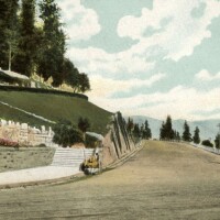
Past generations of Angelenos knew Chavez Ravine well as the home of the city's first arboretum (1893); then a sanatorium for tubercular patients (1902); and later still a naval reserve armory (1940).


So how did a city forget about a canyon with such a storied past?
In part, we can blame its present-day anonymity on confusion between the canyon and the nearby community that shared its name. Sometime after the first residential tract was subdivided in 1904, the community borrowed the name of the nearby canyon. (Presumably, real estate developers did not like the sound of "Sulphur Ravine.") But Angelenos were still aware of the canyon named Chavez Ravine, clearly marked on street maps by the path of Chavez Ravine Road.
Was there also a more willful forgetfulness at work? Dodger Stadium was meant to be a proud civic achievement, a modern baseball palace that signaled L.A.'s arrival as a big-league city. Images of bulldozers and forced evictions, broadcast by sympathetic news media, threatened to sour the moment. Perhaps not coincidentally, the city quietly erased references to Chavez Ravine -- both the neighborhood and the canyon -- even after bulldozers had turned the last of the houses to rubble. In March 1962, mere weeks before the first crowds poured into Dodger Stadium, the city replaced street signs along Chavez Ravine Road. When the new signs went up, they announced a new road name: Stadium Way.


