Hiking the Ghostly Tracks of Forgotten Trains

L.A. used to be covered in train tracks. And then, one by one, they all seemed to disappear.
Well, not all of them. The new Expo Line is actually running on old tracks that were abandoned for years, but kept in place in neighborhoods like Cheviot Hills where they were taken over by feral cats.
But in this age of adaptive reuse, we're increasingly converting land once dedicated to industrial purposes into parks, bike paths, and hiking trails.
Although rail trails are a great resource for their local communities, many of them should be considered destinations. Their phantom switches, markers, rails, and ties tell stories of travel and transport, history and happenings, and the growth of Southern California, outwards and upwards.

The Burned-Out Remains of Mount Lowe Railway
Balloonist Thaddeus Lowe was quite a character, and made Mount Lowe quite the destination during the "golden age of hiking." But if you had money, instead of walking, you could buy a ticket for the incline railway that would take you from Rubio Canyon to Echo Mountain.
Back then, you could stay at a tiny mountain resort town called "White City," or you could transfer to a trolley that would wind its way up the mountain to the old Alpine Tavern.
Most everything up there has burned down, but there are plenty of building foundations to explore, as well as some old tracks and railroad ties. You can explore the old incline railway grounds by hiking through the Cobb Estate along the Sam Merrill Trail from Altadena to the apex of Echo Mountain, where the former railway originally reached its peak.
If you want to keep going, you can follow the Alpine Division trolley's old right-of-way up the mountain on foot, where you'll pass the Cape of Good Hope, the old site of the Circular Bridge, Dawn Station, and Sentinel Rock, which is still in tact. Thanks to the Scenic Mount Lowe Railway Historical Committee, each point of interest along the railroad bed is marked with interpretive signage and historical photos, so you can really imagine the harrowing ride that it must've been, zig-zagging up that mountain.

The Ghost of the Red Car
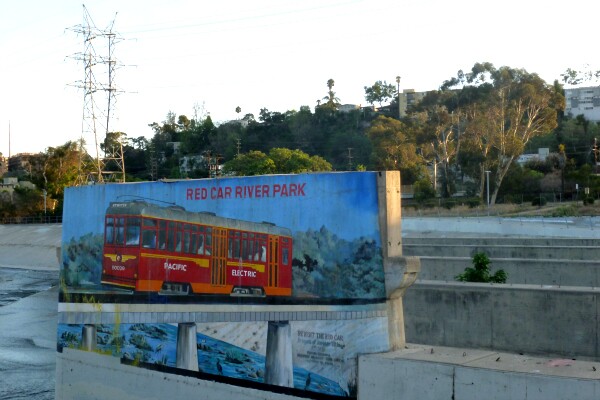
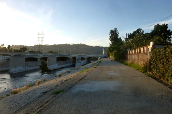
There are vestiges of the Pacific Electric Red Car everywhere around L.A. -- along our boulevards and in our tunnels, but they've faded into the landscape of our growing, car-centric metropolis. If you want to avoid vehicular traffic altogether and walk in the shadow of the old streetcar, visit the former Red Car River Park, just under the Glendale-Hyperion Bridge over the L.A. River. It's where the Glendale/Burbank Red Car line once crossed over the river -- first over a wooden bridge that washed out in 1928, and then across a concrete bridge, whose footings still remain.
Until 1955, Pacific Electric's Glendale/Burbank Red Car line passed through this part of Atwater Village on its way to Glendale and Burbank, then returning to the Subway Terminal in downtown L.A. But before it hit Atwater, it trolleyed through Silverlake (then "Edendale") and across the Fletcher Red Car Viaduct, a bridge that was eventually put out of business by the construction of the 5 Freeway.
Now, these concrete footings of the former streetcar bridge support the Red Car Pedestrian Bridge — which opened in 2020 to connect both sides of the river (along the Los Angeles River Bike Path) and the communities that surround it. The steel-truss bridge — part of the Glendale-Hyperion Bridge complex — is open to pedestrians and bicyclists, as well as equestrians and their horses. Enter by bike from the established path or by foot where Ferncroft Road meets Glendale Boulevard. No cars (or trains) allowed!

Whittier Greenway
At just over nine miles round trip (and soon to be extended), the Whittier Greenway is a worthy destination with its preserved bridges and trestles that are fun to cross. This is a multi-use rail trail, so bicyclists are sharing the asphalt with pedestrians and runners, but it's not generally crowded, and you can find parking at either end. This formerly abandoned Union Pacific Railroad grade closely parallels and then crosses over Whittier Boulevard, a main thoroughfare in Whittier and a key figure in lowrider car cruising culture that still exists today. On the renovated trail, you'll pass schools, parks, shopping centers, and even some industrial facilities -- understandably so, since this is where freight trains once ran.
Armagosa Valley Rail Trail
In the town of Tecopa, outside the southeast corner of Death Valley, you can hike along a route that once transported borax through Death Valley and the Amargosa Valley.
Once you get through the overgrowth, past the ruins of a saloon and up and over the undulating trail, the remnants of the old Tonopah & Tidewater Railroad become apparent, and the trail takes you up and over on top of the old railroad bed. The railroad was supposed to extend from Tonopah (a former mining town north of Vegas) all the way to Tidewater in Southern California but as the local mining business dried up, and an even bigger abundance of borax was found in Boron, the T&T railroad was never extended to its full route.
Now railroad ties leading to nowhere stick straight out from the hillside. This natural area near the Old Spanish Trail attracts a variety of birds, bats, and other wildlife. To access this and other trails, you must pay a visit to the privately-owned China Ranch, an old resting stop founded in the 1890s by Ah Foo from China that's now a working date farm, where you can get some date nut bread to snack on during your trek.

Historic Railroad Trail, Lake Mead
In the Lake Mead Recreation Area outside of Las Vegas, there's a trail where you can hike right through big old decommissioned construction railroad tunnels -- each about 300 feet long and 25 feet in diameter. This newly-designated national recreation trail is the only remaining section of the Hoover Dam railroad system, which was built in 1931 to carry equipment and supplies to construct the Hoover Dam. The tracks have all been dismantled, but how cool is it to walk the path of those steam and gas locomotives that remained in use until 1961? There are five red volcanic tunnels along the seven-mile trail, which you can start at either end -- the Hoover Dam parking structure, or the Lake Mead National Recreation Area Alan Bible Visitor Center. You'll get great views along the way, whether you're hiking or biking. Just be sure to stop at the Lakeview Overlook for a photo opp.