Where to Find SoCal's Most Fascinating Mining Destinations

Southern California and California’s Central Valley have always been better known for the “black gold” spouting from their oil wells than for its precious metals.
That’s not to say that there weren’t plenty of mines and mining companies here – but alongside the gold and silver lodes of Bodie and Calico, miners also dug for sulfates like gypsum, silicates like talc, minerals like tin, and a wide variety of salts.
Not to mention the gravel quarries you still see in rocky areas today.
The various abandoned mines and mine claims within easy driving distance from SoCal are too numerous to name here – so, here are six of the best road trips for exploring mining history in our mountains, deserts and lakes.
1. Big Horn Mine, Angeles National Forest
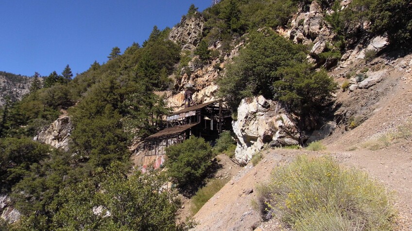
When you think of gold mining in California, the first places that come to mind might be farther north in the Gold Country of the Sierras or the “Gold Fever Trail” of the Holcomb Valley near Big Bear. But we’ve got our very own gold-mining ghost town right here in Southern California – and it hasn’t yet been turned into an amusement park or roadside attraction like Knott’s Berry Farm in Buena Park or Eagle Mining Company in Julian. You can find it in Angeles National Forest near the Vincent Gap parking area, whose namesake Charles Tom Vincent had been hunting bighorn sheep in 1891, when he discovered a gold-bearing quartz vein at what was to become Big Horn Mine. By the turn of the century, it had become a 10-stamp mill surrounded by a bona fide community of cabins, a general store, a post office, and an assay office. They even had telephone service.
The mine was abandoned in 1936 and no prospecting activity has taken place since the 1980s – and it never quite lived up to the hype that surrounded its establishment. But while the rest of the mines that filled the hillsides of the San Gabriel Mountains have been sealed off, erased from modern maps, and forgotten about, Big Horn Mine is the one that’s got a maintained trail to access it. It’s now being preserved in place as the 277-acre parcel has been under the stewardship of the USDA Forest Service since 2011.
The former mining camp is accessible on foot by hiking along an old wagon road, built by California Mining Company, which purchased Big Horn Mining Company in 1901. The trail hugs the east slope of Mount Baden-Powell (named after Lord Robert Baden-Powell, the founder of the modern Boy Scouts, in 1931). After a rainy season, it’s likely to be washed out and a bit harrowing, so wear sturdy shoes and carry a walking stick for extra support. When you get to the main wooden superstructure, tread lightly, and be careful of rotting wood framework, unstable floor slats, and other common hazards of an abandoned site. And while you’re up there, keep your eyes open for Nelson's bighorn sheep along the high, rocky cliffs!
You’ll need an Adventure Pass to park at Vincent Gap, which is located within the Sheep Mountain Wilderness and is accessible along Angeles Crest Highway just southwest of Wrightwood. Take the trail heading left marked “Mine Gulch.” At an unmarked fork, head left to see Vincent’s Cabin or go right to get straight to the mine site. You’ll only gain a few hundred feet along the hike – but you’ll be at about 7,000 feet above sea level, an elevation that can trigger altitude sickness.


2. Borax Visitor Center, Boron
If you’ve already explored the history of borax throughout present-day Death Valley, you’ve only gotten half of the story (if even that much). To get the rest of it, you need to head south to the town of Boron, located just six miles west of the junction of the 395 and 58 highways.
Past the security kiosk for U.S. Borax and up a winding road to the top of a hill, you’ll find a museum dedicated to the history of boron, the town named after the element, the commercial product borax, and the 20 Mule Team that took 20 days to bring 20 tons of it out of Death Valley – until a more plentiful supply was found in the town of Boron in the Mojave Desert. The “harvest” that followed created California's largest open pit mine, which is still an active worksite operated by Rio Tinto.
Among the displays outside the Borax Visitor Center are original ore carts, headframes, and a 190-ton truck tire from a 739 Cat truck. Inside, you’ll get more of the history and the industrial legacy of borax mines – as well as a sense of the commercial element to the element, which is used in a variety of soaps, detergents, and even glass.
The processing facility itself is closed to the public, but the Visitor Center is open every day from 9:00 a.m. to 5:00 p.m. (weather permitting), except major holidays. Admission and parking are both free. And if you don’t get your fill of borax history at the visitor’s center, head back down the hill to the Twenty Mule Team Museum, also in Boron. Although it’s unaffiliated with Rio Tinto and U.S. Borax, it tells more of the same story through its displays of mining artifacts and equipment and antique machinery. It’s also intriguingly located in one of the old houses from the old mining camp of Borax employees.


3. Wall Street Mill and Lost Horse Mine, Joshua Tree National Park
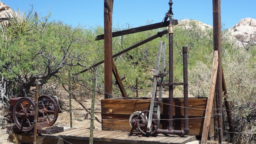
To see a largely in-tact stamp mill for milling gold ore, embark on a relatively easy hike to Wall Street Mill in Joshua Tree National Park. In addition to the mill itself, which is cordoned off with barbed wire, the trail brings you past a windmill, concrete foundations, and a couple of 1930s cars that had been driven off the side of the road to their final resting place.
But Wall Street Mill isn’t the only former site of gold mining in the park. In fact, about 300 mines – some even pre-dating the Gold Rush – were built in the area until concerns about disrupting the wilderness helped designate Joshua Tree as a national monument (and 60 years later, a national park). Few of the businesses built in the wilderness were successful anyway, as many of the ranchers, miners and homesteaders succumbed to the hot, dry desert and fled, leaving behind gravel pits, shafts, and tunnels for bats.
Another well-preserved mining camp is the Lost Horse Mine. It’s accessible via a loop trail that clocks in at 6.2 miles – although if you take the trail clockwise, the Lost Horse mine site is only two miles in, at which point you can turn around and make your hike a 4-mile out-and-back. The whole thing is clearly marked with signage, even as the single-track trail follows along a narrow ridge and a broad wash crosses several loose, gravely roads. Remains of the Optimist Mine are also clearly visible right off the trail, including a chimney – but the real payoff here is the Lost Horse Mine site. There, you’ll get a clear view of the valley below and another stamp mill looming on the hill above.


4. Searles Lake, Trona
Driving north of the Trona Pinnacles, you’ll see big piles of white along Highway 178 and what may look like a dry lakebed. The town of Trona itself may look like a ghost town – but with the formation of the Searles Valley mineral plant (formerly known as American Trona Corporation), Trona became, and still is, a company town. Trona has a rich history as a mining town, its primary source being that dry lake, whose natural minerals are abundant enough to create a number of salt compounds and boron products. Searles Valley Minerals harvests minerals from Searles Dry Lake and processes them at three local plants.
The dry lake is full of minerals – mostly salt and boron – that can be processed into industrial and consumer products, such as compounds like borates (boric acid and borax) and sodium carbonate (soda ash) and sulfate – major ingredients in detergents and other cleaning products. In fact, Searles Lake contains one of the world’s richest deposits of naturally occurring minerals, with brine that's 10 times saltier than seawater. Raw minerals are trucked into the plants, where they’re dried out and bleached.
The main plant is closed to the public – except open once a year, during the annual Gem-O-Rama event in the fall. That’s when you get to actually go out onto the dry lake and dig through the mud, salt, and brine to do a little “mining” of your own.
But there are plenty of other ways to explore Trona’s mining history. You can learn all about how Trona relies heavily on rail to export its products at The Trona Railway Museum, which features a historic caboose, built and delivered to Trona in 1958, among its many displays. The Trona Railway (the short-line railway owned by Searles Valley Minerals) used it until the early 1980s – but now, you get to climb up into it to walk through mining history and imagine all of the freight that has been hauled, the missions it’s been on, and the distances it's traveled. The museum also features some rail- and non-rail-related industrial cast-offs, like a bag-printer machine and an 8-inch valve used in the Borax Refinery of the Trona Plant.

5. Ghost Towns of Owens Lake, Owens Valley
Although technically freshwater, Owens Lake was pretty salty when it still had water in it. At 17 feet deep, it consisted of 7% dissolved solids (sodium carbonate and sodium bicarbonate, sodium chloride, sodium sulfate), making its water more "brine" than anything else. Before L.A. came along and snagged the water rights, local industrialists and entrepreneurs tried to capitalize on the lake’s salt deposits. They created innovative ways to evaporate the water out and isolate the salt solids, so that they could be used for industrial purposes. The lake's "virtually inexhaustible” reserve of sodium carbonate – from which they could obtain soda ash – became big business. Soda ash production started in 1887, and almost all soda ash in the U.S. came from Owens Lake until 1920, when the majority of the nation's supply shifted to Searles Lake.
When the LADWP came along in 1913 to divert the Owens River into its aqueduct, the lake began to dry, and its salts began to crystallize. The local plants had to figure out how to adjust their processes to the changing constitution of the brine, since the Owens Lake water had become too concentrated to recover its mineral deposits by their previously successful methods of solar evaporation. They could no longer ferry their material back and forth between the eastern and western shores of the lake by boat, between Swansea and Cartago. With the receding shoreline, the docks ended up on dry land – and by 1924, the lake was no longer navigable. As a result, mining companies perfected a process that required a particular composition of the brine, a balance that was thrown out of whack when there was both too much fresh water and too little of it.
Now that it’s officially a “dry lake,” companies like U.S. Borax/Rio Tinto continue to mine the salt compounds out of it – and the last thing they want is more water in Owens Lake. In fact, during the floods of 1937-8, the LADWP diverted water from its aqueduct into the lake – and it put mining companies out of business. And they did it again in response to the heavy snowpack of 1967-8, when they deliberately breached the aqueduct to allow the snowmelt to flow into lake, putting more companies out of business.
You can see the results in the ghost towns along the lake's western shore – including Bartlett (home of the former Columbia-Southern Chemical Plant), Cartago, and Olancha (former home of Pacific Custom Materials, which specialized in pumice aggregate) – and its eastern shore, including Dolomite, Swansea, and Hawley (now known as Keeler). In the mining town of Dolomite (named after the white sparkly rocks that contain the mineral dolomite), former home of Inyo Marble Works, all that remains is a historical marker at Dolomite Loop. Keeler was once the center of the mining boom throughout the greater Owens Valley area (with stakes in zinc, silver, lead, and limestone), but mostly what remains of its former glory is the old Sierra Talc Company and a dried-up beach resort.


6. Mammoth Consolidated Mine, Mammoth Lakes
To understand Mammoth today, you have to go back to its mining days – because, as it turns out, the present-day area was not named for the great beasts that roamed the land during the Pleistocene epoch. It wasn't even named for the monumental mountain that overlooks it, but rather the Mammoth Consolidated Mine.
Although the mining boom began in Mammoth (the "Mammoth Lode") as early as 1887 in the Lakes Mining District, most of the extant structures along this particular interpretive trail at Red Mountain date back to Mammoth Consolidated's time operating there, which was only from 1927 to 1933. The claim only produced about $100K worth of gold before its principle proprietor, Arch Mahan, switched his focus from mining to recreation, purchasing the Reds Meadow Pack Station in 1934.
Protected by both the U.S. Forest Service (as Mammoth is technically in the Inyo National Forest) and the Antiquities Act of 1906, the Mammoth Consolidated site is well preserved in its state of ruin. Starting with the former miners' bunkhouses (covered in tar paper, no electricity), take the loop trail for a self-guided tour of more than a dozen sites in a state of arrested decay to explore. The former mine office has been flattened by snow, but the superintendent's former house still stands (sort of). Across from the early 1920s-era assay office (where the purity of the gold was tested), you’ll find the mill area for ore processing and amalgamation and the air compressor plant upon the hill that rises 100 feet above.
Mammoth itself may not be located in Southern California per se, but plenty of Southern Californians make the drive or hop on a quick flight for a weekend getaway there all year long. You can only visit the former mine site during the summer, as the access road to it is closed in winter. To get there, take the free Orange Line shuttle bus to the Coldwater Creek campground in the Lakes Basin area, and walk through the parking lot towards the Duck Lake Pass Trailhead. You can also see the site by horseback with Mammoth Lakes Pack Outfit.


