How to Access Tejon Ranch, California’s Largest Private Parcel

If you’ve ever driven the 5 Freeway through Angeles National Forest and Los Padres, or through the high desert on the other side, you’ve passed Tejon Ranch.
Maybe you’ve even seen the sign for it – but for many, what Tejon Ranch is and what happens there is an utter mystery.
It got its name after soldiers found a dead badger (or “tejón”) at the mouth of the canyon. The name stuck – at least until 1843, when Tejon Ranch was established during the Mexican rancho period. It’s so sprawling, it’s comprised of no less than FOUR former Mexican land grants: Rancho el Tejón, Rancho de Castac, Rancho Los Alamos y Agua Caliente (which translates to “Cottonwoods and Hot Springs Ranch”), and Rancho La Liebre (or “Ranch of the Jackrabbits”). They were all awarded between 1842 and 1846.
The ranch changed hands several times over the course of history – from the Beale family (and war hero Lt. Edward Fitzgerald Beale) to newspaper magnate Harry Chandler and land developer Moses Sherman.
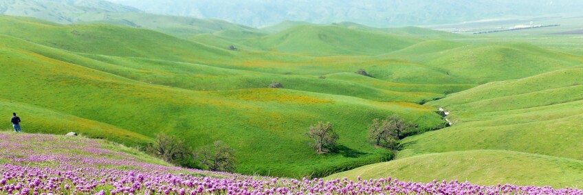
Strategically positioned between mountains, valley, and desert, much of it has been conserved and remains relatively undeveloped. It’s managed to stay kind of a secret – across the high desert of Cañon del Gato Montes (“Wildcat” Canyon), other mountain and valley terrains, and the oak woodlands of Cañon de las Osas (“Bear” Canyon).
Wildlife-tracking trail cams find evidence of incredible biodiversity – black bears, mountain lions, deer, elk, antelope, wild boar, bobcats, gray foxes and coyotes. The skies may reveal some condors, hawks and even golden eagles.
Agriculture thrives there: the crops found at Tejon Ranch include orchards of pistachios, almonds, and walnuts, as well as vineyards of wine grapes. Citrus groves and fig trees were once planted there as well.
It’s not open to the public beyond the gates, though its owners have leased out parcels of land and developed areas like The Outlets at Tejon, which Tejon Ranch Company co-owns. And there’s more development where that came from.
But there are proper ways in. And sometimes, you might be on Tejon Ranch property without even knowing it.
Whether you’re an avid naturalist, a land use historian, or an urban planning enthusiast, here are five of the best ways to explore the past, present, and future of Tejon Ranch, the largest contiguous parcel of privately owned property in the state.
1. The Grapevine Canyon Settlement

To understand Tejon Ranch, it’s important to know that as many as five Native American tribes once dwelled within its present-day boundaries. The Yokuts occupied the area just east of Grapevine Canyon (named “Cãnada de las Uvas” because of the abundance of grapevines found there) – basically where the 5 Freeway runs now, through the Tejon Pass. The Chumash also lived at the mouth of Grapevine Canyon and along Tejon Lake (now Castac Lake, in Lebec), although their lands extended much farther. And the Kitanemuk lived east of Castac Lake and throughout the foothills of the Tehachapi Mountains. In the far western end of the Antelope Valley near the present-day town of Gorman, you could find the Tataviam. They each spoke their own unique language. And when other tribes from the north (in Santa Barbara) and south (in Los Angeles) escaped the mission system, many fled to Tejon Ranch.
Tejon Ranch Conservancy conducts occasional tours of the ranch (frequently during wildflower season), which meet in and take you through Grapevine Canyon. From there, you’ll visit a Native American burial ground, located in the last occupied area of the pan-tribal Sebastian Indian Reservation, established in 1853 as California’s first Indian reservation but abandoned in 1864. A schoolhouse, where many of the members of the Tejon Tribe living in the Indian settlement were educated, is still standing in ruins.
The Conservancy will also take you along roads that are often hard to discern amidst the overgrown, lush, green turf – past old corrals, posts sticking up out of the ground, and other vestiges of ranching days gone by. In the area of that first Grapevine settlement, naturalist docents will also point out mortars, bored out of bedrock outcroppings by grinding up acorns and other foods, where colorful lichen now grows, surrounded by yellow fiddlenecks (likely Amsinckia eastwoodiae). Some of them are “rain rocks,” used to collect water.
In addition to allowing limited public access and providing educational programs, Tejon Ranch Conservancy – part of a consortium that also includes Audubon California, Endangered Habitats League, Natural Resources Defense Council, Planning and Conservation League, and Sierra Club – works with Tejon Ranch Company to “protect, enhance and restore” the Ranch’s “native biodiversity and ecosystem values.” To learn more about its stewardship mission, join one of its community drives or hikes, or sign up to volunteer.


Explore More Regional History
2. A Wildflower Blanket, various locations
The 4WD vehicles owned by Tejon Ranch Conservancy are also a great way to travel to fields of spring wildflowers – not the least of which is Owl's Clover (Castilleja exserta), the white-tipped, pink and maroon puffballs that are common to the nearby Antelope Valley and can extend as far as the neighboring Mojave Desert. Your guides will also point out the California native Bird's eye gilia (Gilia tricolor), Red maids (Calandrinia ciliata), wild hyacinth (Dichelostemma capitatum), blue dicks (Dichelostemma capitatum), popcorn flower (genus Plagiobothrys) and the “wolf” of wildflowers, Bentham’s lupine (Lupinus benthamii).
Although the timing of wildflower season can be unpredictable – peaking one year in February and in June another year – many of these blooms and more can be found throughout the San Joachin Valley portion of Tejon Ranch. More reliably, you can also find dark orange and yellow bursts of the Tejon poppy (Eschscholzia lemmonii), sometimes called “Lemmon’s poppy,” a species that’s endemic to California but generally not found elsewhere in the state. Even more rare is the threatened striped adobe lily (Fritillaria striata) – because if the grazing cattle don't eat them, they trample them.
On your way to Los Alamos Canyon in Tejon Ranch – also with the Conservancy – you’ll pass through mixed oak woodlands, including the blue oak and Valley oak, as well as sycamores, cottonwoods, and stream-side willows. Driving north out of the Antelope Valley into the Mojave Desert, you’ll come across a different sort of woodland: a Joshua tree forest, the population of which is dense, and still growing. If you get the timing right, you might see these Yucca blooming AND fruiting at the same time. It's amazing that after such a short drive, the landscape can so quickly transition from chaparral to high desert – and then transition out again – all inside the bounds of one singular, privately owned ranch.


3. Fort Tejon State Historic Park, Lebec
This mini ghost town of barracks and mess halls and other military facilities is actually only half of the original U.S. Army outpost of 1856 – the other half having been obliterated by the 5 Freeway and Tejon Ranch. What remains at this now designated California State Park is a looped trail around the old fort parade grounds, past the former headquarters of the 1st Dragoons and regimental band and their barracks. Along the parade route, there are kitchens, messhalls, outhouses and the Quartermaster's Office. There’s also Captain Gardiner's Quarters, whose basement once housed preserved lizard, frog, snake and toad specimens collected for the Smithsonian.
It may seem like it was all music and merriment during Fort Tejon's heyday, but there was a dark side to it, too. Apparently, its prisoners were treated harshly – locked up in poorly ventilated, dark, freezing cold jail cells. Not surprisingly, many of those jailed figured out how to escape in the middle of the night. And underneath one of the 400 year-old valley oak trees lies the body of Peter Lebeck – who, according to lore (and his headstone), was killed by a grizzly bear. His epitaph had been carved into a tree, but now a more permanent grave marker memorializes this mysterious figure. Fort Tejon also houses the graves of six enlisted men in a small military cemetery – all of whom died sometime between 1855 and 1864, when the fort was abandoned.
Although the fort was only active for 10 years, it's been considered historically significant enough to be preserved. Some adobes, like the Orderly's Quarters, have been fully restored to reflect a historically accurate portrait of the period. Other structures, like the Officer's Quarters and the bakery, have been stabilized as a living ruin. Reduced down to only their foundations, they give an intriguing “before and after” view of the work that’s been done elsewhere to return the site’s structures to a historically accurate representation.
Fort Tejon is free to visit, with free onsite parking. Its buildings that contain interpretive exhibits are open from 9:00 a.m. to 4:00 p.m. daily. The park grounds are open sunrise to sunset. For overnight accommodations, reserve campsites online.


4. The Ridge Route, Lebec to Castaic Lake
The wide highway stretch now known as the Grapevine is far less treacherous now than the first narrow road that was built and, over time, periodically expanded and straightened out – the infamous “Ridge Route.” Before it opened, there was no good way to get from Southern California to the Central Valley (or back). Stagecoaches and wagons could make it, but the trek over the Tejon Pass was harrowing, to say the least. And because of drainage issues, dirt roads north of L.A. often became muddied or downright flooded. So, the newly formed State Bureau of Highways carved out a road, high up along a mountain ridge to keep the puddles away (not taking into account the snowpack of the harsh winter seasons), by using horse and mule drawn-scrapers and graders, smack-dab in the middle of Tejon Ranch-owned land.
The Ridge Route took automobilists around 697 curves so harrowing, cars could only tackle them safely at a maximum of 15 mph. Although an engineering feat at the time, it quickly became obsolete. Its two lanes were bypassed in 1933 by a straightened, three-lane alternate (with a center "suicide lane" for passing) that became Highway 99 and shortened the journey by nearly 10 miles. Three years later, Tejon Ranch Company was incorporated and continued to manage lands on both sides of the freeway – even as it was widened to become the eight-lane behemoth it is today. But even when it opened in 1970, the 5 didn’t completely erase the Ridge Route.
Today, a very civilized, paved portion of the route runs alongside it in Gorman, a common pit stop for travelers needing to fill or empty their tanks. Since renamed Gorman Post Road, you can see some original curbs along the road shoulder, some dated 1924 (although the Ridge Route's first iteration actually opened in 1915). In fact, at the southeastern terminus of Gorman Post Road, west of where Quail Lake reservoir is now, you can actually drive on a flat, well-preserved stretch of the Ridge Route that dead-ends. To follow the original path of the Ridge Route, you've got to get off of Gorman Post Road and turn left onto Lancaster Road (a.k.a. Hwy 138) and drive 2.5 miles to the signed juncture with Old Ridge Route Road. Although its alignment did change – and portions of it were even buried with the construction of the California Aqueduct – a stretch of this "miracle of modern engineering" is both drivable and maintained.
The most famous stop between L.A. and Bakersfield was a midpoint waystation known as Sandberg, whose lampposts across the street beckoned travelers (no truckers or dogs allowed) to stop at its Summit Hotel, located near the peak of the Ridge Route at 4,100 feet of elevation. Although the county no longer maintains the road past that point, you can still drive on it – at least, until you hit a locked gate. After you round Horseshoe Bend, the big payoff (and your best turnaround point) is the site of the ruins of the Tumble Inn (later, the Mountainview Lodge), with a replica of its original stone arch. For maps and more information on exploring the Ridge Route, visit the Ridge Route Communities Museum and Historical Society in Frazier Park, which occasionally conducts guided tours.


5. The Future of Tejon Ranch
While much of Tejon Ranch is still undeveloped, it’s not exactly untouched. Key pipelines, fiber optic cable and other communication transmission lines already run through it. Infrastructure for gas and electricity utilities and telecommunications companies (including all major cellular carriers) crosses it. The Ranch also leases land to aggregate and limestone mining operations, including National Cement. The Ranch is currently negotiating the placement of large-scale solar facilities on its property, following in the footsteps of IKEA’s distribution center which features the state’s second-largest roof-top array of photovoltaic solar panels, at the a 1,450-acre Tejon Ranch Commerce Center in unincorporated Kern County.
In 2008, the Tejon Ranch Conservation and Land Use Agreement was signed to assure the permanent conservation of up to 90% of the Ranch’s land. That includes the development of six villages in a community designated as Grapevine, which will have unprecedented access to the Ranch’s open spaces. Also in the works are the “mountain resort community” of Mountain Village at Tejon Ranch and the recently approved “master planned mixed-use residential community” of Centennial at Tejon Ranch, to be located on the site of the former General Petroleum (later Mobil) pumping plant and Pacific Telephone and Telegraph Relay Station in the westernmost portion of the Antelope Valley, Los Angeles County.
In the meantime, the notoriously exclusionary Tejon Ranch is becoming more inclusive, with additional opportunities to visit – and even sleep there. Tejon Ranch has partnered with Explore Ranches to accommodate overnight guests in one of its four private lodges at three locations across the Ranch. Otherwise, you can join its hunt club for access to its campsites and hunting lodges, while helping control the population of (particularly destructive and non-native) feral pigs.


