Five Awesome Detours North of Santa Barbara

Before the automobile, you wouldn’t be able to travel between Santa Barbara and the Santa Ynez Valley without making a pit stop or two. Those were the stagecoach days – largely between 1860 and 1901 – when you and your team of horses would need a break on your journey between San Francisco and Los Angeles.
The route along the San Marcos Pass is easier now, thanks to paved, graded roads and an engineering marvel of a bridge that crosses the steep canyon.
You can zip along this two-lane shortcut through Los Padres National Forest, which is more direct (though hillier) than its replacement, the 101 through Gaviota Pass – but that doesn’t mean you should.
It may be a scenic bypass, but you shouldn’t let its attractions pass you by.
From Native American history to watery recreation and a solid meal, here are five reasons why you'll want to divert off California State Highway 154.
1. Chumash Painted Cave State Historic Park
Founded in 1976, Chumash Painted Cave State Historic Parkis one of California’s smallest state parks – and one of the few that provides up-close access to view Chumash rock art. The Chumash people of the Santa Barbara area (also known as the Barbareños) used black, red and white natural pigments to “paint” the walls of a sandstone cave with complex imagery that now befuddles modern scholars.
These priceless paintings could be some of the oldest surviving art in the country – some images could date back as early as the year 1000. However, “cave painting” in this area stopped when the Chumash encountered Spanish conquistadors and missionaries in the 1700s. Since then, vandalism and wind erosion has threatened its preservation – so, a locked gate has been installed at the cave entrance to mitigate the forces working against its survival.
The Chumash Painted Cave may be a small monument – with just a few steps to climb to get to it – but it’s so significant that it’s sparked countless studies to try to figure out its meaning (and inspired at least one beer, Painted Cave IPA by Figueroa Mountain Brewing).
To find it, take a two-mile detour off Highway 154 to Painted Cave Road. Parking here can be a challenge, since the winding road is so narrow with so many blind curves. It’s free to visit and open dawn to dusk. While you’re there, sign the guestbook and let California State Parks know what your interpretations of the paintings are.


Explore Near Santa Barbara
2. Knapp’s Castle
Tucked away in the former Santa Barbara Forest Reserve (now Los Padres National Forest), high above the Santa Ynez Valley, is the path to Knapp's Castle. Businessman, civil engineer, and chemical magnate George Owen Knapp (founder of Union Carbide) built this mountain lodge on his parcel of land in the Santa Ynez Mountains, which he called "Laurel Springs Ranch," and completed in it 1920. It burned to the ground in the 1940 Paradise Canyon Fire – only months after Knapp had sold the sprawling property off. All that remains now are some stone foundations, the frames of huge picture windows, some stairs, and, of course, the incredible scenery as seen from 2,800 feet of elevation.
Knapp's "Castle" – as it became known after the fire – has become a popular hiking spot, despite the fact that it is still privately owned. Its current owners have allowed public access, which – as the front gate reminds you – can be revoked at any time. They've also made some changes to the property, including the addition of some amphitheater-style steps made of native stone, without securing the proper permission. Construction ceased after a "stop work" order was issued – but the site remains littered with construction equipment. For now, you can still wander about the ruins, exploring the various fireplaces and chimneys, and taking in the view (including of the reservoir, which hadn't been built yet at Knapp's time).
Knapp's Castle is relatively easy to reach by foot – its long, winding driveway (the Freemount Fuel Break) accessible off East Camino Cielo (the “sky road”), a turnoff from the San Marcos Pass that was built, graded, rerouted and improved in the late 1800s. Park off the pavement in one of the dirt turnouts, about 1.2 miles east of the East Camino Cielo Lookout. Look for the locked gate (but don’t park directly in front of it).


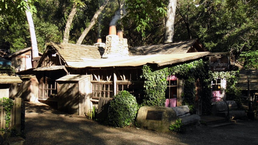
3. Cold Spring Tavern
Just 15 miles north of Santa Barbara in Los Padres National Forest, along what is now known as Stagecoach Road (initially Santa Ynez Turnpike Road), you’ll find Cold Spring Tavern. It was a stagecoach stop starting in 1868, while the Santa Barbara and Santa Ynez Turnpike Road Company was still building the old stagecoach route. Construction on the route was completed by 1870 – and the horse-drawn stage line once carried both passengers and mail between Santa Barbara Mission and the mission's farm in Rancho San Marcos, now known as the Santa Ynez Valley.
The San Marcos Pass was so steep that every stage stopped at the tavern (then known as the "Cold Spring Relay Station") to add two more horses to the team. The current antiques/gift shop used to be a bunkhouse for the "mudwagon" drivers, who usually had to stop to switch out their horses. But once motor vehicles took over – and the pass had been paved – the stage line ceased operation in 1901. And over time, the use of the Cold Spring property changed from restaurant to rest stop to hotel (1893-7) and back to restaurant, of which members of the Ovington-Wilson family have been in charge continuously since 1941.
Nowadays, this former stage stop is a time capsule of the late 19th century – between both its original structures and some relocated ones, like the Ojai jail, built in 1873. It was relocated to Cold Spring in 1959 after the City of Ojai wasn't interested in keeping it as a historical artifact. So, the two-room pokey was trucked over the Santa Ynez Mountains and parked here (making it "the only jail that ever crossed a mountain," according to "Ripley's Believe It Or Not"). Several railroad packing crates were bought in 1941 and brought here as well – including one that was used as a tavern from 1942 to 1947, until the owner at the time decided to move in and use as her residence. She named it "Blisshaven" – which loosely translates as "safe harbor" or "peaceful home."
Completing the compound are relics from the ghost town of Gopherville – which got plowed with the widening and shoring up of the Gaviota Pass, its remnants relocated here after 1951 – and the Road Gang House, where Chinese immigrants railroad workers stayed. Next to the Gang House, there's an old ore car that was used at a silver and gold mine from the early 19th through the early 20th centuries. Yet so many motorists end up bypassing all these artifacts altogether, not knowing how “worth it” the detour is. “Time may march on,” an inscription on the tavern menu reads, “but here at the Tavern we do our best to stop it.”


4. Cold Spring Canyon Arch Bridge
To fully understand the undertaking that making this journey once was by stagecoach, you've got to take a side trip to Cold Spring Canyon Arch Bridge. Don’t just drive across it along Highway 154 – because when you do, you might not even notice you’re crossing a bridge at all. And it’s such a deceivingly quick trip, you can’t really tell how high you are just by looking out your windshield.
To view it from below, go a bit farther down Stagecoach Road past Cold Spring Tavern. Standing under this massive marvel, you can see its reinforced concrete foundations up close and gaze up at the clean, geometric lines of its girders, trusses and arches. The result is a bridge that’s efficient, structurally sound, and aesthetically pleasing.
At 400 feet above the canyon floor, it’s the highest arch bridge in the country and the highest of any bridge in California. Constructed for $2 million in 1963 (opened to traffic in 1964) as a “shortcut” to span 700 feet across the gorge below and circumvent the sharp curves of the old route from Santa Barbara to Lake Cachuma and beyond, the welded steel bridge was cheaper than the original Caltrans plan to build Highway 154 by burying the Tavern under 125 feet of dirt.


5. Cachuma Lake Recreation Area
When driving north from Santa Barbara to Los Olivos or Santa Ynez, it’s hard not to notice the big, glimmering body of water over to the right. That’s Lake Cachuma, Santa Barbara County’s second-largest reservoir, with a 190,409-acre-feet capacity. The Bradbury Dam formed it when it was built across the Santa Ynez River and completed in 1953. Then called the Cachuma Dam, the earth and rock dam was part of the Cachuma Project to provide a local-based water supply for various communities in Santa Barbara County. In 1971, it was renamed to honor local water advocate, C. W. "Brad" Bradbury, a former chairman of the Santa Barbara County Water Resources Division.
The dam still operated and maintained by the U.S. Department of the Interior Bureau of Reclamation to collect, store and use flood flow waters. You can check it out at the Cachuma Lake Vista Point – but if you only stop there, you’ll be missing out on the rest of the 9,000-acre Cachuma Lake Recreation Area. Flanked by the picturesque Santa Ynez and San Rafael Mountains, this recreation area offers an abundance of opportunities to commune with nature along the lake’s 42-mile shoreline and surrounding area within the San Rafael Mountain Range Watershed.
Start your visit at the Neal Taylor Nature Center, an interactive mini-museum housed inside a historic ranch house. Founded in 1988, this is where you’ll find naturalists offering guided nature walks Saturdays 10:00 a.m. - 11:30 a.m. If you’d rather venture out on your own, the hiking trails include the 2.5-mile (one way) Sweetwater Trail between the Bradbury Dam Overlook and the campground at Harvey Cove, the half-mile Oak Canyon Nature Trail and the quarter-mile Mohawk Loop.
Even though the “lake” provides drinking water, you can actually recreate on it – as long as there’s no body contact with it (like swimming). Two-hour nature cruises run mornings and afternoons every Friday, Saturday and Sunday all year except on Christmas Day. For a fee, passengers ages 5 and up can board a 30-passenger pontoon boat to observe bald eagles (November through February) and other wildlife (like the Western bluebird) and wildflowers the rest of the year (March through October). Or, rent your own boat or kayak for a more leisurely pace, and spend the night in one of the many camping facilities offered.


