The Lost U.S. Highways of Southern California History

US-101 still traces the spine of Spanish California. US-395 continues to parallel the eastern escarpment of the Sierra Nevada. And US-66 charts a direct course to a gauzy, nostalgic past. But these are mere vestiges of our first interstate highway system, one that linked Southern California to the nation with concrete pavement and black-and-white shields.
Soon after a joint board of state highway officials adopted the 50,100-mile United States Numbered Highway System in 1926, you could have cranked up your Model T on the Lake Michigan shore, followed signs for US-66, and in 2,451 miles your tires would be kicking up Santa Monica sand. Or, starting at the Peace Arch that straddles the U.S.-Canada border, you might have followed signs for US-99, and within a couple days you'd be cruising past the downtown department stores and movie palaces on Broadway.
These U.S. numbered highways calmed the chaos of the some 250 named national auto trails that preceded them. Most of the highway routes used pre-existing, state-maintained roads, which became eligible for funding through the Federal Aid Highway Act. Standardized signage -- including the distinctive route markers modeled after the official United States shield, but also the now-familiar system of octagonal stop signs, rectangular directional signs, and diamond-shaped warning signs -- made the roads safer and easier to navigate.
Route numbers -- now commonplace, but then an innovation -- also kept motorists on the correct path. And the system bundled a lot of meaning into each one-, two-, or three-digit number. Odd numbers marked north-south routes and grew larger toward the west; US-1 hugged the Atlantic coast, and US-101 the Pacific. Similarly, the even numbers of east-west routes grew larger toward the south. Trunk lines contained one or two digits (US-95); their tributaries earned a prefix (US-395). Numbers ending in "0" or "1" were reserved for highways of truly national scope (US-60 or US-91); shorter routes ended with "2" through "9" (US-99). (The two great exceptions to this scheme were US-66 and US-101, both considered first-order highways.)
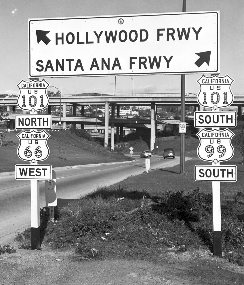


At the system's zenith, nine U.S. highways bound the Los Angeles region with the nation:
- Route 6: Long Beach to Provincetown, Massachusetts
- Route 60: Los Angeles to Virginia Beach
- Route 66, Santa Monica to Chicago
- Route 70: Los Angeles to Atlantic, North Carolina
- Route 91, Long Beach to Sweetgrass, Montana
- Route 99: Calexico, California, to Blaine, Washington, by way of Los Angeles
- Route 101: San Ysidro, California, to Olympia, Washington, by way of Los Angeles
- Route 395: San Diego to Laurier, Washington, by way of Riverside and San Bernardino
- Route 399: Ventura to Bakersfield
Where they traversed farmland or open desert, these highways were lonely ribbons of concrete. Where they entered town, they became Main Street. In Pasadena, for instance, Colorado Blvd. was signed as US-66. In Anaheim, US-91 was Center Street.
By the 1960s, however, the next generation of interstate highways -- those federally-funded freeways that bypassed rural towns and blasted through urban neighborhoods -- had rendered many of the older routes obsolete. I-15 replaced stretches of US-66, US-91, and US-395. I-5 claimed US-99's role as the trunk line of the Pacific states. I-10 supplanted US-60 as L.A.'s primary link with Arizona and points east.
In 1964 California scrubbed most of these defunct highways from official maps. But a few simply traded their black-and-white US highway shields for the green spades of the California state highway system. CA-91 courses through Santa Ana Canyon, connecting Anaheim with Riverside along the former path of US-91. A truncated CA-99 still barrels north through Bakersfield, Fresno, and Modesto, the Central Valley cities once served by US-99. And, like US-60 before it, CA-60 skirts the Puente Hills on its final approach to downtown L.A.
Further Reading
Kaszynski, William. The American Highway. Jefferson, NC: McFarland & Company, 2000.
McNichol, Dan. The Roads That Built America. New York: Sterling, 2006.
Weingroff, Richard F. "From Names to Numbers: The Origins of the Numbered U.S. Highway System," AASHTO Quarterly 76 (Spring 1997): 6-16.


