In Plain Sight: Photographic Recordings of Police Violence (Lincoln Heights)

After nearly thirty years of struggle and continued efforts to be more inclusive and diverse, the country is once again in the throes of unrest, clamoring for real change. As the nation strives for answers and ways forward in the wake of George Floyd’s death, it is helpful to look back. How did we get here? How can we help make lasting changes? Read on to learn more.


This photo essay is one in a series titled "In Plain Sight: Photographic Recordings of Police Violence" by Kwasi Boyd-Bouldin.
Police brutality and the use of excessive force is a topic at the forefront of our national conversation. To many, this subject seems unrelated to their daily lives but in reality, these events take place on street corners, at convenience stores and on the sidewalks of our neighborhoods. Although the re-emergence of the subject in the national media is somewhat recent, questions of departmental transparency, guidelines and police accountability have been an issue in Los Angeles for decades.
The goal of this project is to document both the surrounding areas and specific places where violent acts involving law enforcement have taken place. Most people move through the city immersed in their daily routines, often oblivious to the events that have taken place on the very streets they traverse. The exploration of these seemingly mundane spaces emphasizes the extent to which society has normalized the use of force by police officers in certain communities and the repercussions of that perspective.
This photo essay is focused on the Lincoln Heights area of Los Angeles. Located just east of downtown, it is one of the oldest working class neighborhoods in the city. The area is primarily composed of residential blocks and a wide variety of small businesses. It is also bordered by large stretches of desolate, industrial spaces and bisected by two major freeways. Law enforcement in this community falls under the jurisdiction of the LAPD Hollenbeck station. This division has recently come under increased scrutiny due to an officer-involved shooting in 2016 that resulted in the death of a teenager in the neighboring city of Boyle Heights.

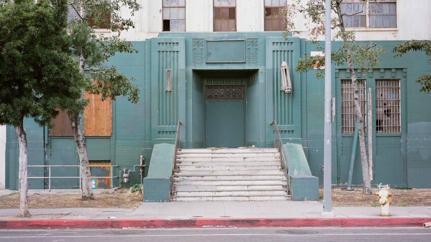
Two of the most prominent architectural landmarks associated with Lincoln Heights, the Los Angeles County-USC Medical Center and the abandoned Lincoln Heights Jail, are included in this essay as registered sites of police-related violence. Although the events that took place at these locations are separated by over 50 years, they serve to illustrate both how long the city has been grappling with the question of what is considered police brutality (or excessive force) and when the use of force is considered justified.
On Christmas Day of 1951, also known as “Bloody Christmas,” seven men were heavily beaten at the Lincoln Heights Jail while in custody by a group of police officers. This scandal rocked the city and eventually sparked calls from the media to hold the officers involved accountable, which was unprecedented at the time. It was one of the first publicly documented examples of police brutality in LAPD history.
The officer-involved shooting that took place a short distance away from the Los Angeles County-USC Medical Center in September of 2016 is a recent case of a public violence that unfolded in front of many eyes. A suspect who had been arrested earlier in the day was undergoing tests at the hospital when he escaped police custody. In the course of his escape attempt, he attempted to carjack a motorist and was shot by the police. This scenario played out within the view of dozens of people, with the well-known hospital serving as the backdrop.