When L.A. Became the Capital of the U.S.-Mexico Borderlands

Posted Mondays, Jeremy Rosenberg's (@LosJeremy) Laws That Shaped L.A. spotlights regulations that have played a significant role in the development of contemporary Los Angeles. These laws - as nominated and explained each week by a locally-based expert - may be civil or criminal, and they may have been put into practice by city, county, state, federal or even international authority
Ed. note: Jeremy Rosenberg is off this week and turns over the Laws That Shaped LA column today to Michael Dear.
Dear is a professor of city and regional planning at the University of California, Berkeley and author of the new book, "Why Walls Won't Work: Repairing the US-Mexico Divide."
This Week's Law That Shaped L.A."¨ Law: Treaty of Guadalupe Hidalgo Year: 1848 Jurisdiction: International Nominated by: Michael Dear
By Michael Dear
On February 2, 1848, a "Treaty of Peace, Friendship, Limits and Settlement" was signed at Guadalupe Hidalgo, thus terminating the Mexican-American war. The war was ostensibly about securing the boundary of the recently-annexed state of Texas, but it was clear from the outset that the U.S. goal was territorial expansion. President Polk saw it as America's 'manifest destiny' to reach the western ocean through the acquisition of Nuevo México and the Californias (which included parts of the present-day states of Arizona, California, Nevada, New Mexico, Utah and Colorado).
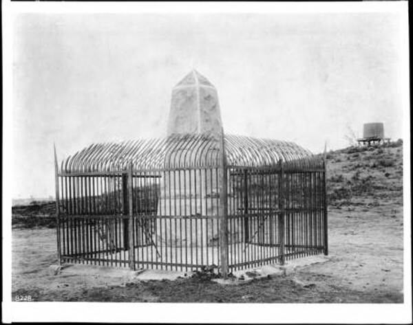
The Treaty of Guadalupe Hidalgo, as it came to be called, required the demarcation and marking the boundary line on the ground. The hard work of the surveys was undertaken between 1849 and 1855 by U.S. Commissioner William Hemsley Emory and his Mexican counterpart, Commissioner José Salazar Ylarregui.
One day, in L.A.'s Central Library, I discovered a diary that Salazar had kept during the first leg of the boundary survey, across California. He had been appointed to the Mexican Commission when only twenty-five-years-old, and already had a prominent career in public affairs. Emory was famous as a military man and explorer before he joined the survey, and Salazar's memoir recounted Emory's unfailing courtesy -- how he communicated through a smile that said: "I am American, but without being treasonous I can, as brother of all men, love Mexicans and love the beautiful Mexican Republic."
Commissioner Emory concurred. At the close of the survey, he wrote that: "the utmost harmony has existed on this Commission between the Officers of both governments, and ... all questions likely to produce the least difference have been settled harmoniously." That such harmony existed between two erstwhile enemies surprised me; but the fact that cross-border conviviality persists to the present day is even more striking.
In 2002, I traveled in the footsteps of Emory and Salazar along the entire length of the US-Mexico border, on both sides, a total of 4,000 miles. What began as a journey of discovery was rapidly overtaken by events. You see, I had the good (and bad) fortune to begin just before the U.S. undertook the fortification of its southern boundary, and so became an unintentional witness to the closing of our southern border. As time passed, I found myself less focused on drug wars, immigration and homeland security, and more on the well-being of the border dwellers in the spaces between the two nations, whose lives had been severely disrupted by the blossoming fortifications. How did this happen?
By the time that the international boundary survey was completed, the frontier spaces that the Spaniards had sought to conquer had been transformed into border places where Mexico and the U.S. sought to secure the fledgling territorial limits of their respective nations. They were only partly successful in these efforts. For most of the second half of the nineteenth century, the border remained an open, violence-prone region.
In 1853, the Los Angeles Rangers was founded in response to the incursion of Mexican bandits and desert Indians into Southern California. Major Horace Bell published an entertaining memoir of the L.A. Rangers, unusual for being short on violence and long on social commentary .Mindful of his readers, Bell set out early to establish L.A.'s lawlessess:
"I have no hesitation in saying that in the years of 1851, '52, and '53, there were more desperadoes in Los Angeles than in any place on the Pacific coast, San Francisco with its great population not excepted. [All the] cut-throats of California and Mexico naturally met at Los Angeles, and at Los Angeles they fought."
L.A.'s ethnic diversity was already well-established by mid-19th century, a characteristic that led Arthur Ellis, in his introduction to Bell's book, to disqualify L.A. as "an American community." It was not a tolerant place, wrote Ellis, brutally referring to the whole state of California as an "ultra white man's government."

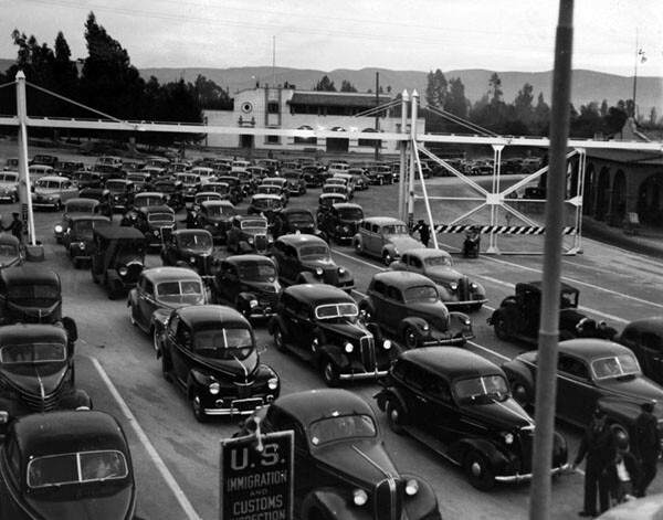
After the Mexican Revolution and First World War, the border zone calmed down and prospered. As the flow of migrants to el norte became more chaotic, the U.S. Border Patrol was created in 1924 to alleviate congestion and confusion. This was the moment when la línea (the line) was born. The space between Mexico and the U.S. was no longer an open frontier, still less a permeable international border; instead it became a line of demarcation, for the first time controlled in the U.S. by a dedicated police force.
Still, cross-border interactions intensified, and connections spread far beyond the border line to embrace more-distant cities and towns. (Think of L.A.'s Prohibition-era attachment to Tijuana's Agua Caliente racetrack, its open bars and nightclubs.) In 1942, provoked by a war-induced shortage of labor, the U.S. Bracero program began issuing identity cards to Mexican nationals who wished to work in the U.S. Over four million workers participated in the program, but when it was officially terminated in 1960, Mexican border towns were clogged by repatriated workers, who frequently remained at the border instead of returning to more-distant home towns. [Related: Read this Laws That Shaped LA column about the Bracero program.]
The Mexican government responded by launching a 'Border Industrialization Program' in 1965. From this grew the empire of the Mexican maquiladora industry, establishing enormous swathes of assembly plants for U.S. manufacturers just across the border in Mexico, taking advantage of tax breaks and relatively low labor costs. Ultimately, two-thirds of all maquilas were established in Tijuana, Mexicali, and Ciudad Juárez. Prosperity brought population growth, and by 1980, many border settlements had been transformed into large 'twin cities,' including Tijuana and San Diego.
Today, the U.S.-Mexico borderlands are among the fastest-growing regions in both countries. The six Mexican border states contain 16 percent of Mexico's population (17 million people) and the four U.S. border states 21 percent of the U.S. population (54 million). Many cities and towns on the U.S. side have a majority Mexican population, and major metropolises such as L.A. and Monterrey (in the state of Nuevo Léon) have been inexorably drawn into the orbit of borderland growth.
Mutual dependence has been the hallmark of cross-border lives for centuries, before the border even existed. The spaces between Mexico and the U.S. can be regarded as a third nation even though it's not truly a sovereign state. Border dwellers possess a shared identity, common history, and entwined futures. People in San Diego and Tijuana readily assert that they have more in common with each other than with their host nations. Others describe themselves as 'transborder citizens.' One man who lives and works on both sides, told me: "I forget which side of the border I'm on."
Now all this is threatened. Following the attacks of 9/11, the U.S. unilaterally adopted an aggressive program of fortifying the entire boundary with Mexico. Hundreds of miles of new fencing have been constructed along the land boundary at a cost of over $2 billion (though coverage is still not complete). The new barriers are buttressed by a doubling of the number of U.S. Border patrol agents (the 'boots on the ground'), plus a new virtual border (the 'eyes in the sky' of high-tech surveillance, including drones).
The current fortifications along the border are without historical precedent. They threaten to suffocate the arteries supplying the third nation's oxygen. The border zone has been incorporated into Fortress U.S.A., consisting of an archipelago of law enforcement and justice agencies dedicated to apprehension, detention, prosecution and deportation of undocumented migrants. These are bolstered by corporate security interests, producing a kind of 'Border Industrial Complex.'
The growth of Los Angeles since 1848 has been linked to the evolution of the US-Mexico borderlands from its frontier days, through its rebirth as an international border and a line of geopolitical demarcation, to its present-day status as a third nation. Even though L.A. now plays a role in the new detention-center gulag associated with the Border Industrial Complex, the region also evinces many characteristics of cross-border coexistence and connectivity, including sanctuary cities, plus deep economic, social, political and cultural ties.
L.A. burst into life as a Spanish/Mexican outpost. By now, it is truly a capital of the borderland's third nation. People of Mexican origin in California rarely tire of pointing out: "It was the border that moved, not us."
Perhaps Hollywood got it right a half-century ago? In the 1957 version of '3.10 to Yuma' the outlaw Ben Wade (played by Glenn Ford) is riding hard toward Mexico to avoid capture. Stopping along the way at a remote saloon, he asks a beautiful woman behind the bar: "How far is it to the Mexican border?" to which she replies: "No-one knows exactly. It's never been decided."
Top: The monument that marks the border between the U.S. and Mexico, photographed c. 1900. Photo courtesy USC Digital Archives.
Have a suggestion for a Law That Shaped LA or someone to interview? Contact Jeremy Rosenberg via: arrivalstory AT gmail DOT com.