In the Heart of the Valley: How to Explore the Sepulveda Basin Wildlife Reserve

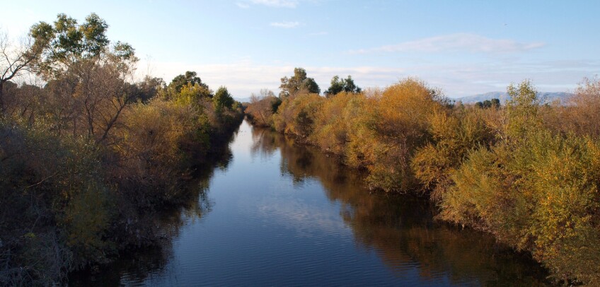
The Sepulveda Basin Wildlife Reserve is one of the few areas on the Los Angeles River specifically set aside for wildlife. In order to protect the wildlife, dogs are not allowed. The Wildlife Reserve is a 225-acre site within the larger approximately 2000-acre park complex of the Sepulveda Basin. It is a joint project of the US Army Corps of Engineers and L.A.'s Department of Recreation and Parks, partnering with community groups.
The reserve features a lake with a bird refuge island, and extensive native plant re-vegetation. This 2.6 mile walk features some of the best and most accessible bird watching in the L.A. basin, informative interpretational signage, and a quiet green refuge from the bustle of its urban surroundings. Binoculars recommended.
Starting Point
Sepulveda Basin Wildlife Reserve, off Woodley Avenue near Burbank Boulevard.
Directions to the Start
By bike: Take the Metro Orange Line bikeway. Turn left at Woodley Avenue and proceed south. Turn left at the second access road (look for the Sepulveda Basin Wildlife Reserve sign), then keep right and continue to the end of the access road. There are bike racks at the entrance gate below the amphitheater.
Explore more about the Sepulveda Basin
By Transit: Take the Metro Orange Line and exit at Woodley Avenue and proceed south to the L.A. River. Walk south on Woodley. Turn left at the access road.
By Car: Exit the 405 Freeway at Burbank Boulevard in Van Nuys. Go west on Burbank Boulevard. Turn right onto Woodley Avenue. Turn right onto the second access road (look for the Sepulveda Basin Wildlife Reserve sign), then keep right and follow the signs to the end of the access road.
Alternately, exit the 101 Freeway in Encino at Balboa Boulevard . Go north on Balboa Boulevard. Turn right onto Burbank Boulevard. Turn left onto Woodley Avenue. Turn right at the second access road (look for the Sepulveda Basin Wildlife Reserve sign), then keep right and follow the signs to the end of the access road.
Walking Directions
Begin at the entry building next to the parking lot. This area includes ample parking, picnic areas, fields, bathrooms, drinking fountain, and an amphitheater. Go through the middle of the building, turn left, and then turn right to take the ramp down along the amphitheater and across the grass field. Enter the wilderness area through the gate on your left and head south on the walking path. (Feel free to leave a donation in the lock box here to help maintain and improve this park.)
On your right, at many points somewhat obscured by vegetation, is Haskell Creek. This creek flows year round with reclaimed water from the Tillman Water Reclamation Plant.
On your left, four short spur trails lead to wildlife-viewing areas. These viewing areas include helpful signs with information about birds, flooding, and more. These spots are excellent for checking out the many birds that frequent the refuge island. It's common to see cormorants, herons, egrets, and geese, and occasionally pelicans and owls. The observation areas are good for just sitting quietly and listening to the bird calls.


After checking out the viewing areas, continue walking south along the path. Cross the outlet for the lake (a spot where egrets frequently hang out), after which the path curves to the left. Go through the gate on your right and into the pedestrian tunnel under Burbank Boulevard. At the end of the tunnel, continue through the gate, then bear right on the dirt path. The path curves left. Haskell Creek is again to your right.
The foliage opens up at the point where Haskell Creek empties into the Los Angeles River, with the Sepulveda Dam floodgates to your left. Although it's not the prettiest part of the river, the size of the channel and the dam give a sense of the powerful floodwaters that are held in abeyance here. This area is kept clear of vegetation to maximize its capacity. (Wheelchair users should double back to the start at this point.)
Continue along the river, downstream toward the dam. At the floodgates, the path turns left and continues along the base of the dam. Just before reaching Burbank Boulevard, turn left on the path to view a pleasant wildlife pond. At the end of the pond path, turn left onto the path paralleling Burbank Boulevard.
Turn right into the tunnel. At the end of the tunnel, take a sharp left onto the concrete path, just before the gate. On your left is a restoration project called Hummingbird Hill, which features flowering native shrubs planted to attract hummingbirds.
At the top of the ramp, turn left to head east along Burbank Boulevard. Past the small parking lot, turn left. Go through the gate. Walk north along the top of the dam, with broad views of the basin, the freeway, and the San Fernando Valley. When you approach the large trees on your left, descend the unmarked diagonal path back down to the visitor center parking lot where you began.
This walk takes in many of the best features of the wildlife area, but there are additional paths to explore. As with nearly all sites along the river, the complexion of the wildlife area changes with the seasons. In winter, you will see large flocks of Canada Geese visiting for the warm weather.
Where to Eat
Zankou Chicken
5658 Sepulveda Boulevard #103
San Fernando Valley, CA 91411
(818) 781-0615
Denny's
5525 N Sepulveda Boulevard
Sherman Oaks, CA 91411
(818) 787-0700


